
Importo totale (1 articolo articoli):
Destinazione ordine:

gerard (Oltre 194.000 risultati)
Vai alla pagina principale dei risultati di ricerca
Tipo di articolo
- Tutti gli articoli
- Libri (191.634)
- Riviste e Giornali (438)
- Fumetti (325)
- Spartiti (179)
- Arte, Stampe e Poster (729)
- Fotografie (47)
- Mappe (579)
-
Manoscritti e
Collezionismo cartaceo (225)
Condizioni
Legatura
Ulteriori caratteristiche
- Prima edizione (11.147)
- Copia autografata (2.270)
- Sovraccoperta (8.329)
- Con foto (59.617)
- No print on demand (177.581)
Spedizione gratuita
Paese del venditore
Valutazione venditore
-
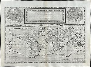
De groote nieuwe vermeerderde Zee-Atlas, ofte Water-Waereld. Vertoonende in zig alle de Zee-Kusten des Aardryks. Bestaande in zeer nette Kaarten, zo platte als wassende Graden: war in ontdekt zyn alle Baayen, Reeden, Klippen, Droogtens, Dieptens, Anker-plaatzen, en alle Strekkingen en Opdoeningen van Landen: ook haar lengten en Polus hoogten, &c. Dienende tot Opbouwinge en Voortplantingte der Scheepvaart, uit nieuwe Opgevingen van Schippers, Stuurlieden en Liefhebbers der Zeevart. Te zamen vergaadert en in't ligt gebragt, door Gerard van Keulen, &c
Editore: By Gerard van Keulen, Amsterdam, 1705
Prima edizione
Hardcover. Condizione: Very good. First. First Gerard van Keulen edition. Amsterdam: By Gerard van Keulen, 1705-1706[-1709]. Two volumes. Folio (24 1/2" x 15", 622mm x 382mm). Vol. I: folding letterpress Dutch title-page in red and black, privilege, blank, 2pp. letterpress French title, blank. With a hand-colored engraved frontispiece-imprint heightened in gilt and 84 (numbered in manuscript 2-3, 6-8, 10-88) hand-colored engraved folding plates. Vol. II: with a hand-colored engraved frontispiece-imprint heightened in gilt and 79 (numbered in manuscript 1-79) hand-colored engraved folding plates. With 2 hand-colored engraved frontispiece-imprints heightened in gilt, and 163 hand-colored engraved folding plates. Bound in contemporary mottled calf (re-backed with the back-strip laid down). On the boards, two panels bordered by gilt rolls. The inner border has at its outer corners armillary spheres gilt. In the center, Atlas supporting an armillary sphere on his shoulders gilt, surrounded by gilt scrollwork. On the spine, eight raised bands. In the panels, armillary spheres. Title gilt to the second panel, number gilt to the third. All edges of the text-block speckled red. Re-backed, with the back-strip laid down. Front boards splayed (vol. I: ca. 85mm split to the calf). Scuffs and some patches of wear (vol. II: wear to the edges of the front board). Internally, considerable pigment burn (II:21 repairs) and browning of green pigment. Tears to two plates (I:70, II:13). Ink manuscript in an early hand translating the titles of most plates into French. Slips reinforcing the lower edges of the stubs of I:6 with ink manuscript notes, calculations and sketches in an early hand. On the verso of the frontispiece of vol. II, a pencil table (with two entries) titled "Table des Cartes contenues dans ce volume" An exceptionally well-preserved, essentially unsophisticated set. Joannes van Keulen (1654-1715) established in 1679 the firm "de Gekroonde Lootsman", the Crowned Pilot. Mapmaking continued by that firm and family for 200 years; it was one of the great publishing dynasties of Europe. Van Keulen had been augmenting the available stock of charts (and other sorts of atlantean plates: celestial maps, tables of flags, images of ships, coastal views) for 25 years when his son, Gerard, took over the firm. The bookselling innovation of the van Keulen atlases was the offer of an essentially custom collection; one could cobble together what one wanted and could afford. There were over 460 van Keulen charts from which to choose; the largest complement ever found in a single atlas is 185. The present copy boasts 163, the most of any copy in auction records. One plate (I:7) is not listed in Koeman as belonging to any other copy: a French-Dutch table of the world's flags signed by Cornelis Danckerts. The presence of that plate points towards the French ownership of the volume. The insertion of the French title-page is recorded by Koeman in concert with a Dutch title-page (dated 1708), but the combination in the present copy is unrecorded. The numeration and the French titling, the stub-slips (I:6) and the pencil table (II:frontispiece verso) are all in different hands. What the layers of annotation indicate is the engagement the owners and users of the volumes. The first stub-slip queries the angle of the sun and its shadows on the verso; the recto has part of a carefully dotted circle and calculations of degrees. Clearly this was a scrap from the notebook of a French navigator. The Dutch color-expert Dr. Truusje Goedings has written of the present copy that the "volumes have been coloured in the same style but probably not by the same hand. . . With its lavishly gilt title-prints, full colouring of the maps and gilt leather bindings this copy most probably was a de-luxe copy as offered by Van Keulen". Koeman IV: Keu 20B (110 plates overlap) Keu 24 (Dutch title-page, not noting the printing in black-and-red), Keu 25 (French title-page), Keu 28 (135 plates overlap, 1708-9).
-
Van Keulen's De Groote Nieuwe Vermeerderde Zee-Atlas ofte Water-Waerld - 183 Originally Hand-colored Maps or Charts
Data di pubblicazione: 1708
Da: Trillium Antique Prints & Rare Books, Franklin, TN, U.S.A.
Valutazione venditore:

Arte / Stampa / Poster
Hardcover. Condizione: Fine. This extraordinary and exceedingly rare atlas is from Johannes and Gerard Van Keulen and entitled in full "De Groote Nieuwe Vermeerderde Zee-Atlas ofte Water-Waerld. Vertoonende in zig alle de Zee-Kusten des Aardryks. Bestaande in zeer nette Kaarten, zo platte als wassende Graden: waar in ontdekt zyn alle Baayen, Reeden, Klippen, Droogtens, Dieptens, Anker-plaatzen, en alle Strekkingen en Opdoeningen van Landen: ook haar lengten en Polus hoogten, &c. Dienende tot Opbouwinge en Voortplantinge der Scheepvaart, uit nieuwe Opgevingen van Schippers, Stuurlieden en Liefhebbers der Zeevaart. Te zamen vergaadert en in â t ligt gebragt, door Gerard van Keulen, &c." The work was published in amsterdam by Gerard van Keulen in 1708 (but 1709). --- This was the largest Van Keulen sea atlas ever issued. Keulen atlases of this size are rarely available. The last notable records we see are Sotheby's in 1984 with 160 charts and Christie's in 2019 with 133 charts. --- Johannes van Keulen (1654-1711) was a Dutch publisher. He was said to have produced â the largest and finest marine atlases in Holland.â (Koeman) He received a privelege from the States General of Holland and West Friesland in order to printe maritame atlases and shipping guides. The privilege was to protect his printed material from illegal reproduction. He named his printing firm, In de Gekroonde Lootsman, which grew to be one of the most successful Amsterdam publishing firms. He collaborated with other cartographers including Claes Janszoon Vooght and Johannes van Luyken. --- Keulen's first atlas, entitled "Zee Atlas", contained only 40 charts. By 1695 his atlas would have 160 charts. His son, Gerard, took over publication in 1704 and expanded the atlas to 185 charts by 1709. --- Gerard van Keulen (1678-1727) was a skilled engraver, mathematician, and chart-maker. He was appointed Hydrographer to the Dutch East India Company in 1714. The van Keulen publishing firm operated continuously from 1678 to 1885 with three generations of the family active in the firm. --- The volume is bound in contemporary Dutch calf gilt, covers with a gilt stamped central armillary sphere within an arabesque, spine in compartments with raised bands gilt. --- Present in the atlas: 183 hand-colored engraved plates and charts (nearly all double-page or folding, with the world map credited to Nicolaes Visscher) 14 of which are coastal profiles, Hand-colored engraved allegorical title page or frontispiece dated 1709 (by Aernout Naghtegael after Jan Lukeyn), Folding letterpress title in Dutch dated 1708, Additional title in French dated 1709, 12 pages of Dutch text, 8 pages of French Text, 5 hand-colored allegorical divisional titles dated 1709. --- The contents collates broadly with Koeman Keu 28 (dated 1709 and containing 185 charts), with the following exceptions: the French letterpress title here is dated 1709 rather than 1707; in Part 2 charts (55)+(56) have been joined to form a large folding chart; charts (60) and (61) have been replaced by â Nouvelle carte marine Generale croissant ende-GrĂ s du Canal â ¦ A New General and Gradual increasing Compass Map of the Channel â ¦â ; chart (86) has been replaced with â Paskaert van Cales tot Cadiz â ¦â ; chart (97) has been replaced with â Pascaart van de kust van Portugalâ ; and there is an additional chart after (105) titled â Nieuwe Pascaert vande kust van Maroca en Zanhagaâ ; in Part 3 chart (111) has been updated with â Nieuwe paskaart van tâ opkomender Straat Gibralter â ¦â ; and two pairs of charts have been joined: (126)+(129), and (127)+(128) to form two large folding charts; and in Part 4 (136) has been replaced by â Paskaert waer in de graden der breedde over weder zyden â ¦â . The Dutch letterpress title is dated 1708 and contains the address of Gerard van Keulen, while the general allegorical title and 5 allegorical divisional titles are all dated 1709 and show the address of Johannes van Keulen. A further letterpress.
-
Terrestrial globe: Cosmotheore, Caelesti nostro Globo, Par, et plane Novus, Hic Terrestris ut existeret, Certo scias, Errore Veterum Sublato, Non tantum Utriusque Orbis, Longitudines ac Latitudines, Par reiterates Neotericorum Observationes, Hicce esse restitutas, Sed et nullum typis Emendatiorem prodiisse, Hoc igitur Novissimô tam diu fruere, Donec sub Majori forma, Meô aere Alios excudam Gerardus Valk Calcographus, Amsterdami, A(nn)o 17(50) Cum privilegio. / Celestial globe: Uranographia, Caelum omne hie Complectens, Illa pro ut aucta, et ad annum 1700 Competum, Magno ab Hevelio, correcta est, ita, ejus ex Prototypis, sua noviter haec Ectypa, veris Astronomiae cultoribus, exhibit et consecrate, Ger. et Leon. Valk, Amstelaedamenses.
Editore: Amsterdam, Gerard and Leonard Valk 1750/1700, 1750
Da: Antiquariaat de Roo, Zwijndrecht, Paesi Bassi
Membro dell'associazione: ILAB NVVA
Valutazione venditore:
A pair of rare Valk table globes published by Gerard and Leonard Valk in Amsterdam in 1700 and 1750. The Dutch globe makers Gerard Valk (1652-1726) and his son Leonard Valk (1675-1746) were the only significant publishers of globes in the Netherlands in the eighteenth century. The design of their globes was completely new and incorporated the latest geographical and astronomical discoveries and are hence the most accurate globes for that time. Valk completed his present 15-inch. (39 cm) globes in 1707 and the copper plates went through several states over the years. The terrestrial globe is here in what Van der Krogt calls state 3 (with the date changed to 1750 by pasting a slip over the "45" of the "1745" in state 2). Leonard Valk made the most important revision to the 1707 topographic image sometime between 1730 and 1745 when he revised the Caspian Sea and the Aral Sea based on a new mapping. The celestial globe is in state 2 (as published ca. 1711, when Leonards name was added to his father's, but it was not further revised until 1745). The Valks apparently numbered each globe they made, stamping the number on the back of the brass meridian ring near the north pole and beginning a new series when the plate was revised. The present terrestrial globe is numbered "3"; the meridian ring of the celestial globe is not original and bears no number. They apparently made very few of these globes, for in the present states Van der Krogt records no numbers higher than 10 for the terrestrial globe or 7 for the globe. The present pair forms a beautiful example of the outstanding work of the Dutch Valk family as globe makers. Each globe was made up of two hollow paper-maché hemispheres joined at the equator and covered with a layer of plaster, the whole covered with eighteen engraved gores and two polar calottes, the celestial calottes on the ecliptic poles. The equator is graduated in individual degrees, the ecliptic in individual days of the houses of the Zodiac with sigils. Each globe has a brass meridian ring and hour dial with a hand-coloured printed paper ring on the wooden horizon ring, showing degrees and the days of the houses of the Zodiac. Each globe supported by four columns with bun feet on a Dutch-style oak stand connected by cross-stretchers supporting a circular base plate, with support for the meridian ring at its centre. Including the oak stand, each globe has a height of 59 cm (23 inches). The last two digits of the year on the terrestrial globe have been nearly obliterated, but one can see that they were formerly covered with a slip, as expected in state 3. The celestial globe has a new stand, a later hour dial and brass meridian ring and its paper horizon ring is in facsimile. Some minor paper repairs in Ethiopia (terrestrial globe) have been professionally restored. Overall in good condition. An extraordinary, eye-catching set of these rare globes. Literature:Van der Krogt, Globi Neerlandici, pp. 313-331, 555-557, globes VAL III T state 3 (4 copies: numbered 2, 4, 8 & 10) & VAL III C state 2 (4 copies, numbered 2, 6, 7 & one unnumbered).
-

Atlantis Sylloge Compendiosa: Cuius in Chartarum Serie, Hic Notes Quod Hasce: A Septentrione Usque Austrum, Descendendo per Earum Latitudines.
Editore: Amsterdam: G. Valck and P. Schenk, 1709., 1709
Folio (20 2/8 x 13 inches). Letterpress title-page with list of contents. Additional engraved allegorical title-page with original hand-colour in full, 99 double-page engraved maps (index including title as first map) with original hand-colour in part (a few very small wormholes at lower edge affecting title and first 13 maps and very small wormhole in upper margin of last 10 maps not affecting engraved area). Fine contemporary Dutch speckled calf, the spine in 9 compartments with 8 raised bands, gilt morocco lettering-piece in one, the others decorated with fine gilt astrolabe tool (spine ends and corners with early repairs). Provenance: with the 20th-century woodcut bookplate of C.J. Tencate on the front paste-down; Christopher Henry Beaumont Pease, Lord Wardington (1924-2005), Library of Important Atlases and Geographies, his sale Sothebys' 10th October 2006, lot 518 A later issue, but a FINE AND ATTRACTIVE COPY. "The first issue is thought to be about 1702, and in this, as in the present copy, the vast majority of maps bear the imprint of Valk and Schenk, as does the atlas of Cellarius produced in 1708, and David Mortier's "Atlas Anglois" in 1715. The maps with dates are from 1683, 1703, 1705 and 1707" (Wardington Catalogue). Gerard Valk and his son Leonard were printers, engravers and globe-makers in Amsterdam, closely linked by marriage with the Schenk family with whom they also had a long business association in map engraving and publishing. With their co-publishers, the Schenk family was amongst the most prolific and best-known publishers of eighteenth-century Amsterdam. Many of the atlases they produced were primarily reissues from earlier printing plates that the family purchased from other cartographers. Their work, though often not original, is finely presented and demonstrates the precision and elegance associated with maps and engravings produced in the period. From the distinguished library of Lord Wardington whose collection of Atlases was unique: "a panoply of the history of cartography and of great mapmakers" (Andrew Phillips "An Appreciation", Sotheby's sale catalogue). Catalogued by Kate Hunter.
-
Hardcover. Condizione: Very Good. 5 parts in one volume. Folio (18 4/8 x 11 inches). Engraved allegorical title-page incorporating the figure of Atlas, 4 engraved sectional title-pages, double-page engraved world map, and 146 engraved maps, all double-page except one, and mounted on guards, with contemporary hand-colour in part, completed more recently (washed and browned, some early marginal repairs). Mottled calf over bevelled boards, brass clasps and catches, antique. First French text edition, translated from the Latin text of 1607 by the historian Henri Lancelot-Voisin de la Popliniere (d. 1608). In 1604, after the death of Gerard Mercator and his son Rumold, the plates for his celebrated maps were sold to the great Amsterdam cartographer, Jodocus Hondius. He issued the first of his "Mercator-Hondius" Atlas in 1606. Hondius supplemented the the original 107 maps with 39 mew maps compiled under his own supervision. These new maps were of were of extremely high quality, and were for the most part devoted to parts of the world, such as America, that had been neglected by Mercator. The present 1609 edition was only the third of the approximately thirty published by the firm of Hondius before the atlas was discontinued in 1641. Koeman II, Me 19. Catalogued by Kate Hunter.
-
Totius Americae Novior Accura[ta] Tabula
Editore: Amsterdam: Gerard Valk, op den Dam inde Wackeren hont, [after 1686]., 1686
Mappa
No Binding. Condizione: Very Good. MAGNIFICENT AND QUITE POSSIBLY UNIQUE COPY of Valk's large 2-sheet engraved wall-map of the Americas, surrounded by a decorative border of separately printed views (overall size: 58 4/8 x 42 4/8 inches; map size: 25 4/8 x 37 inches, two sheets joined vertically), the fine map of North and South America, with the title "America" in an elaborately historiated and allegorical cartouche lower left, Valk's imprint upper right, "cum Privilegio." lower centre, a beautiful north polar projection upper left, and decorated with numerous galleons, two compass roses, rumb lines, and an historiated scene to match that of the title cartouche lower right; the whole beneath a superbly illustrated title banner "Totius Americae Novior Accura[ta] Tabula", printed in three sections, decorated with scenes of Native Americans meeting European soldiers and royalty, native plants and animals, including iconic images of a turkey and an eagle; the side and lower borders are surrounded by 14 separately engraved vignettes of the countries, ports and towns of the Americas, each with a pair of figures in local costume in the foreground by Aldert Meyer; all with exceptional original hand-colour in full, backed on the original linen (green oxidized and occasionally brittle or chipped, light browning); float-mounted and framed with original wooden rollers, which have been coated in gesso and hand-painted. Provenance: with Sotheby's May 2013, who reports that this map, one of a pair with "Aisia" "were in an 18th-century villa between Florence and Siena, but the origin of the family is Piedmont". Valk's two sheet map of the Americas is EXCEPTIONALLY RARE: Burden (625) reports one copy without the separately printed border panels, in the Mellon Collection at Yale Center for British Art; one copy with the border, exactly as here, and quite possibly this one, in a castle near Prague; and this cataloguer has not been able to identify another example. In 1686 Valk received his privilege, which he announces proudly along the bottom edge of this map, and shortly afterwards moved to the address recorded in the imprint of this map. However the cartography belongs to a decade or so earlier and is derived from the Jan Mathisz wall map of ca 1655, "the plates of which are believed to have been in the possession of the Visscher firm at the time. Like the Mathisz he utilises the earlier Briggs form of California as an island with a straight northern coastline. A similar inset map with a north polar projection complete with matching decoration is also included" (Burden). This information was also used by Nicholas Visscher II in his wall map "Nova totius Americae tabula" (banner title) of 1680, which was reissued by Petrus Schenck in about 1706. The separately printed views that make up the splendid border of the wall map are identical to those by Aldert Meyer (born 1663 or 1664) found in the engraved plates of Carolus Allard's celebrated "Orbis habitabilis Oppida et Vestitutus" (published between 1683-1698), although the backgrounds are clearly not by Thomas Doesburgh (fl. 1683-1714), as they are in Allard's book. It is tempting to think that these may precede those of Allard's book, but it is also possible that they are copies. Each view is captioned "Cum Privilegio Ordinum Hollandiae et West-Frisia" and are, clockwise, of: Sinus Omnium Sanctor[um] - Bahia de todos sanctos, or the Bay of All Saints, south along the Atlantic coast from Pernambuco; Nieuw Amsterdam - New York; Havanna Portu; Campetie - St. Franciso de Campeche in the Yucatan; Straet Davis en Hudson - the Davis Strait, Labrador; Trugillo - Trujillo in Northwest Peru; Callaodelim - Callao in Peru; Peru; St. Antonio Vaz, in Brazil; Caput. S. Augustin, in Brazil; Porto Rico; Boa Vista, in Brazil; Canada; and Aux Nassovii, in Brazil. Gerard Valk and his son Leonard were printers, engravers and globe-makers in Amsterdam, closely linked by marriage with the Schenk family with whom they also had a long business associa.
-
Atlas, sive Cosmographicae Meditationes de Fabrica Mundi, et Fabricata Figura.
Editore: Amsterdam: Jodocus Hondius, 1619., 1619
Prima edizione
5 parts in one volume (17 x 11 2/8 inches. Engraved allegorical general title-page, and 4 sectional title-pages, double-page double portrait of Mercator and Hondius, double-page engraved world map (Shirley 157, chipped with minor loss along a vertical crease), and 1554 double-page maps, and one full-page map, all with original hand-colour in outline an in part (map of America chipped with minor loss along a vertical crease, some small marginal repairs). Modern panelled pigskin over oak bevelled boards antique, brass clasps and catches. THE FIRST TRUE "ATLAS"-THE WORD CHOSEN BY GERARD MERCATOR TO DESIGNATE A COLLECTION OF MAPS AND ONLY LATER ADOPTED BY ALL GEOGRAPHERS Later edition of Mercator s celebrated "Atlas", published after Mercator s death by his son Rumold. For nearly sixty years, during the most important and exciting period in the history of modern mapmaking, Gerard Mercator was the supreme cartographer, his name, second only to Ptolemy, synonymous with the form of map projection still in use today. Although not the inventor of this type of projection, he was the first to apply it to navigational charts in such a form that compass bearings could be plotted on charts in straight lines, thereby providing seamen with a solution to an age-old problem of navigation at sea. The influence of his revolutionary ideas transformed land surveying, and his research and calculations led him to break away from Ptolemy's conception of the size and outline of the continents. Unlike the work of Abraham Ortelius, a contemporary and equally celebrated cartographer, Mercator's maps are original. While Ortelius engaged in the reduction and generalization of already existing maps, Mercator checked current knowledge of the earth's topography against its fundamental sources and drew maps in an original manner. Mercator was born in Rupelmonde in East Flanders. He studied in Louvain under Gemma Frisius, a Dutch astronomer and mathematician, and began his career as a cartographer in that city, where the excellence of his work eventually won him the patronage of Charles V. In order to escape religious persecution, he moved in 1552 to Duisburg. There, he continued to produce maps, globes and instruments, including his most celebrated work, a world map on eighteen sheets drawn to his new projection (1569). In later life he devoted himself to the preparation of his three-volume collection of maps to which, for the first time, the word "atlas" was applied. The word was chosen, he wrote, "to honor the Titan, Atlas, King of Mauritania, a learned philosopher, mathematician, and astronomer." Mercator's sons and grandsons were all cartographers and made their contributions in various ways to the great atlas. His son Rumold, in particular, was responsible for the complete edition of 1595. But Mercator's work only received the universal acclaim that it deserved when Jodocus Hondius bought the copper printing plates from the cartographer's heirs in 1604. In 1606 the first Amsterdam edition of the Mercator Atlas appeared. From then to 1638, the atlas saw many enlarged editions in various languages. Koeman Me 26B. Catalogued by Kate Hunter.
-
Atlas or a Geographicke description of the Regions, Countries and Kingdomes of the World. Translated by Henry Hesham.
Editore: Henry Hondius and John Johnson, 1636
Libro
Hardcover. Condizione: Very Good. Amsterdam: Henry Hondius and John Johnson, 1636. 2 volumes. Folio (19 x 13 inches). Engraved title-pages with letterpress overslips over titles and one imprint, double-page engraved portrait of Mercator and Hondius, 196 double-page engraved maps, the first five with some hand-colouring in outline (one or two maps shaved, map of Lungeburgh with tape repair just obscuring a portion of the border, some dampstaining in volume two, some edges a bit frayed, occasional browning and a few repaired tears). Modern quarter calf, marbled paper boards (spines faded). Provenance: With the near contemporary inscription of Thomas Huntington (fl. 1645-1656), publisher with T. Jackson, at the sign of the Princes Arms, Duck Lane, recording the sale of these volumes: "December 20th 1656, I do warrant these two Bookes to be perfect & Compleate for which I have received four pounds Sterling. Witness my hand Tho: Huntington", tipped-in before the engraved title-page of volume one; the engraved armorial bookplates of Sir Robert Abdy (1688-1748), 3rd Baronet, of Albyns, Essex, Member of Parliament for Essex (1727-1748), on each paste-down; the ownership inscription of Elijah Hart of Liverpool, dated 1835 on the front paste-down of volume one; the penciled ownership inscription of S.H. Rathbone, M.D. at the head of the title-page of volume one; Christopher Henry Beaumont Pease, Lord Wardington (1924-2005), Library of Important Atlases and Geographies, his sale Sothebys' 10th October 2006, lot 289. The English edition of the Mercator-Hondius Atlas, containing twenty new maps. Numerous other maps have been corrected and improved, and in some cases new vignettes have been added, first published in co-operation with Cornelis Claesz in 1606. "Jodocus Hondius obtained the copper-plates of Mercator's atlases (Ptolemy's "Geographia" and the "Atlas") on 12 July 1604. He probably bought them at Leiden at the auction of Mercator's library, then in the possession of his grandson, Gerard Mercator, Jr. A partly new text to the maps was written by Petrus Montanus. after [Jodocus Hondius's] death, the widow with her seven children continued publishing the atlases under the name of Jodocus Hondius till 1620. The firm was reinforced by the very welcome help of Joannes Jansonius (1588-1664), who married 24-year-old Elizabeth Hondius in 1612. After 1619 the Atlas was published under the name of Henricus Hondius [Jodocus Hondius's son] (Koeman). From the distinguished library of Lord Wardington whose collection of Atlases was unique: "a panoply of the history of cartography and of great mapmakers" (Andrew Phillips "An Appreciation", Sotheby's sale catalogue). Koeman II, Me 41A and 41B (v2); van der Krogt 1:341.1a and 1:341.2B.
-
Atlas.
Editore: Judoci Hondij,, Amsterodami,, 1613
Da: Daniel Crouch Rare Books Ltd, London, Regno Unito
Membro dell'associazione: ABA ILAB PBFA
Valutazione venditore:

Libro
The first 'atlas' Folio (480 by 330 mm), engraved title heightened in gold, (3) pp, engraved portrait of Mercator and Hondius, (9) pp., 374 pp., 45 double-page engraved maps, engraved half title (Galliae) heightened in gold, 30 double-page and one single-page engraved maps, engraved half title (Germaniae) heightened in gold, 29 double-page engraved maps, engraved half title (Italiae, Slavoniae et Graeciae) heightened in gold, 45 double-page engraved maps, 18 ff, full original hand colour throughout, 150 maps in total, contemporary mottled calf, spine divided into seven sections with raised bands, gilt, restoration to capitals and lower back. A fine example of a great atlas. Gerard Mercator (1512-1594) would not begin his great 'Atlas' or 'Cosmography' until relatively late in life. The impetus for this came when he was employed as cosmographer to Duke William IV of Kleve, in 1563. Mercator's intention was to produce a work that consisted of five books and covered the whole world. The first book would cover the creation; the second the heavens; the third geography; the fourth history; and the fifth chronology. He intended to draw all the maps, write all the text, and cut all the plates himself. Unsurprisingly, the ambitious project would require more time than he could afford to give it, and he was only able to complete a few of the parts: the creation; the maps for Ptolemy's 'Geographia' - part of the geographical section - in 1578; and four of the modern parts. The first three were published together in 1585 and covered France, the Low Countries, and Germany. The fourth part, covering Italy, the Balkans, and Greece, appeared in 1589. Mercator died on December 2, 1594, leaving the responsibility for completion of the cosmography to his son Rumold. Mercator's work is referred to as the first atlas, because he was the first to give a collection of curated maps this name, reflected in the famous engraved title-page showing King Atlas measuring the world with a pair of dividers. It is often wrongly thought that the word 'atlas' refers to the Titan of the same name, whose punishment for fighting against the Olympian gods was to hold the heavens on his shoulders. King Atlas was a mythical ruler of Mauritania, a mathematician and philosopher who supposedly made the first celestial globe. There was one further edition in 1602 before the plates were acquired by Jodocus Hondius (1563-1612). This is the second French edition printed by Hondius, both times adding groups of new maps to the book. Together with the 1613 Latin edition, it is the first to contain the famous double portrait of Mercator and Hondius engraved by Hondius' widow Colletta van den Keere, a successful publisher in her own right who continued the business after her husband's death. The title-page of this copy states "Editio Quarta" (i.e., the fourth Latin edition), but it is in fact a variant of the 1613 French edition, with the Latin title-page but French text (as in Koeman). There are examples of the 1613 French edition at the Scheepvaart Museum, Amsterdam, and the Lilly Library, Bloomington, Indiana, and an example with a Latin title in the University Library, Leiden. Collation as in Koeman II 23A, but title page as in Koeman II 23B; van der Krogt I 1:112; Shirley (2004) T-MER 2g (Latin 1613).
-

Sociedad Informe, La - Gerard Imbert
Editore: Icaria editorial, 2010
ISBN 10: 8498883059ISBN 13: 9788498883053
Libro
Condizione: New. Libro nuevo, sellado, fisico, original. Enviamos a todos el mundo por USPS, Fedex y DHL. 100% garantia en su compra. Sealed, new. Unopened. 100%guarentee. We ship worldwide.
-
Galliae Tabule Geographicae. -- Belgii Inferiores Geographicae Tabule -- Germaniae Tabule Geographicae.
Editore: Duisburg: [not after 1595]., 1595
Folio (16 2/8 x 11 2/8 inches). Three engraved title-pages (the first with early abrasion where ownership inscription has been erased) and 50 fine double-page engraved maps, and one full page, all with fine contemporary hand-color, descriptive letterpress on the recto of each map, each verso blank, woodcut initials, single blank leaves bound in before the first maps in the Netherlands (Belgii) and Germany sections (last map of Hungary, with early hot wax stains to verso affecting the image). Contemporary limp vellum, yapp fore-edges, title in manuscript on the spine, map of Germany with symetrical closed marginal tears, extending 4 inches into the image). Provenance: early marginal note to +v. Mercator's earliest collection of modern maps, first issued in 1585 by Gerard Mercator, initially issued separately or combined with the second part "Italia" published in 1589. This copy conforms with Koeman's collation for the issue of the three parts as they were published as part of the first Mercator atlas "Atlas sive Cosmographicae", 1595, issue A [Koeman Me13A], although this copy does not include the portrait and has the dedication dated 1585. Koeman argued that the resetting of the text was indicative of the later 1595 issues. Other authorities have argued against this hard and fast rule. The uncolored copy in the Nordenskiold Collection [Nordenskiold 2, 138] conforms broadly to this copy, although with its later binding may well have been taken from a 1595 issue of the larger atlas. It is highly likely, given the popularity of Mercator's work, that the stocks of the 1585 issue ran out before Mercator's death in 1594. Gerard Mercator was paralysed by a stroke in 1590, and the existence of this atlas in its contemporary binding suggests that Gerard or Rumold had the text reset well in advance of the completion of the full atlas, and had continued to sell the three parts as a single volume. Mercator was born in Rupelmonde in East Flanders. He studied in Louvain under Gemma Frisius, a Dutch astronomer and mathematician, and began his career as a cartographer in that city, where the excellence of his work eventually won him the patronage of Charles V. In order to escape religious persecution, he moved in 1552 to Duisburg. There, he continued to produce maps, globes and instruments, including his most celebrated work, a world map on eighteen sheets drawn to his new projection (1569). In later life he devoted himself to the preparation of his three-volume collection of maps to which, for the first time, the word "atlas" was applied. The word was chosen, he wrote, "to honor the Titan, Atlas, King of Mauritania, a learned philosopher, mathematician, and astronomer." Mercator's sons and grandsons were all cartographers and made their contributions in various ways to the great atlas. His son Rumold, in particular, was responsible for the complete edition of 1595. Koeman Me13A. Catalogued by Kate Hunter.
-
Estudios, De Granel, Gerard. Serie N/a, Vol. Volumen Unico. Editorial Arena Libros, Tapa Blanda, Edici n 1 En Espa ol
Editore: Arena Libros, 1900
ISBN 10: 8415757433ISBN 13: 9788415757436
Libro
Condizione: New. Libro nuevo, sellado, fisico, original. Enviamos a todos el mundo por USPS, Fedex y DHL. 100% garantia en su compra. Sealed, new. Unopened. 100%guarentee. We ship worldwide.
-

Hemispheriu ab Aequinoctiali Linea, ad Circulu Poli Arctici / Hemispheriu ab Aequinoctiali Linea, ad Circulu Poli Atarctici.
Exemplaire extręmement rare publié séparément de la carte du monde emblématique de de Jode.Cette carte est tellement emblématique qu'elle a été utilisée comme carte de couverture de l'ouvrage Mapping of the World de Shirley. Elle est magnifiquement présentée dans une projection en double hémisphčre polaire. C'est l'une des premičres cartes ŕ ętre présentées de cette maničre.SourcesCette carte est une adaptation intéressante de la carte du monde de Guillaume Postel de 1581 et d'une carte anonyme publiée ŕ Anvers en 1587. Les deux cartes présentent le męme schéma pour les côtes septentrionales - le golfe de Merosro en Amérique du Nord, le placement de Ter. d Labrador et Nova Zemla, et l'étrange jonction de la partie orientale de l'Asie avec l'une des grandes masses arctiques. Le Japon se trouve ŕ quelques degrés seulement de la côte ouest de l'Amérique, et la délimitation de l'Afrique du Sud et de l'Amérique du Sud présente d'autres caractéristiques qui suggčrent fortement une source commune.La carte puise également ses connaissances géographiques dans les cartes italiennes de l'école Lafreri. De Jode aurait acquis ces cartes sources auprčs d'agents de cartographes vénitiens et romains.États et éditionsBien que trčs rare, cette carte peut ętre trouvée sur le marché comme étant extraite du Speculum, atlas de De Jode, avec un texte au dos. Burden reconnaît l'existence d'une carte sans texte dans ses sources mais n'a pas pu en localiser une copie. Il note : "Il a été rapporté que des feuilles de cartes sans texte ont été publiées séparément avant l'édition de l'atlas de 1593". Burden mentionne, toujours selon ses sources, une carte sans texte avec l'inscription Cornelius de Jode 1590 que l'on ne retrouve pas sur notre exemplaire qui est donc antérieur.Burden 184 // ENGLISH // A seriously rare, separately published copy of de Jode's iconic world map.This map is so iconic that it was used as the cover map for Shirley's Mapping of the World. It is beautifully presented in a double polar hemisphere projection. It is one of the first maps to be presented in this way.SourcesThis map is an interesting adaptation of Guillaume Postel's world map of 1581 and an anonymous map published in Antwerp in 1587. Both maps show the same pattern for the northern coasts - the Gulf of Merosro in North America, the placement of Ter. d Labrador and Nova Zemla, and the strange junction of the eastern part of Asia with one of the great Arctic masses. Japan lies only a few degrees from the west coast of America, and the delineation of South Africa and South America has other features that strongly suggest a common source.The map also draws its geographical knowledge from the Italian maps of the Lafreri school. De Jode would have acquired these source maps from agents of Venetian and Roman cartographers.Condition and editionAlthough very rare, this map can be found on the market with a text on the back as being taken from De Jode's Speculum atlas. Burden acknowledges the existence of a map without text in his sources but has been unable to locate a copy. He notes: 'It has been reported that sheets of maps without text were published separately before the 1593 edition of the atlas'. Burden mentions, again according to his sources, a textless map with the inscription Cornelius de Jode 1590 which is not found on our copy which is therefore earlier.We could only locate one other copy of this map.Burden 184.
-

Iconic Map of the World from Polar Projections (Hemispheriu ab Aequinoctiali Linea, ad Circulu Poli Arctici / Hemispheriu ab Aequinoctiali Linea, ad Circulu Poli Atarctici.)
Editore: Antwerp, 1593
Da: Trillium Antique Prints & Rare Books, Franklin, TN, U.S.A.
Valutazione venditore:
Arte / Stampa / Poster
Condizione: Fine. This world map entitled Haemispheriu Ab Aequinoctiali Linea is one of the most rare and important world maps ever published. Shirley notes that Cornelis de Jode would have used the more recent map from Guillame Postel in 1581 as well as recently published anonymous gores from 1587. Most cartographers were deriving their map from Mercator's world map of 1569, which makes his double-polar projection world map noteworthy. (Shirley 184) This world map serves as the cover of Shirley's The mapping of the world one of the most important reference works on maps.Description of the work:This truly significant map is from one of the rarest atlases ever published, Gerard and Cornelis de Jode's Speculum orbis Terrae. The work was published in Antwerp in 1593 by Arnold Coninx for the widow and heirs. This is considered the second edition, revised an expanded. The first edition was published in 1578. Van Ortroy knew of only 14 copies of the second edition being published. (Skelton, Introduction to the facsimile editions)De Jode drew upon his large stock of maps from Italian, German, and Flemish cartographers to create his atlas. He engraved some of the maps and his brothers, Joannes and Lucas van Deutecum, also contributed to the process. The second edition included additional maps from Gerard's son Cornelis. The maps have descriptive text to verso in Latin. The text for the first edition was written by the German scholar, Daniel Cellarius.The atlas contained some of the most groundbreaking maps ever published. The maps of the world, Americas, Australia, and China are of particular note and remain some of the most important maps ever published. While it may not have had commercial success at the time, it is considered a masterpiece of 16th century cartography. Very few examples of the maps have survived from either edition.Gerard de Jode (1521- 1591) was a Flemish cartographer, printer, and engraver. He produced and sold many maps in Antwerp, but his legacy lies in his outstanding atlas, Speculum Orbis Terrarum. De Jode was a contemporary and competitor of Abraham Ortelius. Ortelius was believed to have been responsible for delaying de Jode's work so his atlas Theatrum Orbis Terrarum would precede de Jode's. Because Ortelius's atlas had 8 years on the market it was well established and thus de Jode's atlas did not sell very well.To compete with Ortelius, de Jode worked on the second revised and expanded edition. De Jode's wife and son, Cornelis (1568-1600) took over the publishing upon Gerard's death in 1591. Cornelis prepared ten new maps of the World, North America, China, Australia and Alaska and re-issued the atlas. "Many of de Jodeâ s maps are judged to be superior to those of Ortelius, both in detail and style." (Burden)Antwerp publisher Joan Baptista Vrients purchased the plates after Cornelis's death. He also acquired Ortelius's plates for Theatrum Orbis Terrarum to which he gave priority. It is likely he bought de Jode's plates to prevent any further editions of Speculum of course only increasing the intrigue and worth of the maps today."Although the atlas may not have appealed to the public, it was admired by other cartographers. As evidence, Petrus Montanus mentions it in the same breath with Mercatorâ s Atlas and Orteliusâ Theatrum in his preface to Pieter Kaeriusâ Germaniae inferior (Wardington Catalogue), Michael von Aitzing refers to it in his work, DeLeone Belgico (1583). Von Aitzing intended his work to act also as a supplement to both the Theatrum of Ortelius and the Speculum of De Jode." (Burden)Provenance : Ownership inscription at the bottom of the title page ex Bibliotheca Prim d Federici 1600.References: Van der Krogt 32:02B (titles 32:2A and 32:2B) ; Koeman II, Jod 2 ; Shirley, The mapping of the world, 165,184 ; Burden, The mapping of America, 81, 82 ; Symour, L. Schwartz, Ehrenberg, The mapping of America, pp. 78-79 ; Norwich, Maps of Africa 19 ; Navari, Maps of Cyprus, 29 ; Tooley, Dictionnary of.
-

Biblia De La Salud Intestinal, La - Dr. Gerard E. Mullin
Editore: GRIJALBO, 2013
ISBN 10: 9502810783ISBN 13: 9789502810782
Libro
Condizione: New. Libro nuevo, sellado, fisico, original. Enviamos a todos el mundo por USPS, Fedex y DHL. 100% garantia en su compra. Sealed, new. Unopened. 100%guarentee. We ship worldwide.
-
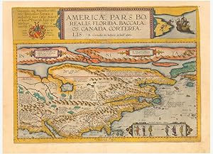
Americae Pars Borealis, Florida, Baccalaos, Canada, Corterealis. A Cornelio de Iudćis in luce edita
Editore: Antwerp, 1593
Da: Neatline Antique Maps, Tiburon, CA, U.S.A.
Membro dell'associazione: ABAA ILAB
Valutazione venditore:

Mappa
No Binding. Condizione: Very Good. The first printed folio map of North America and the most iconic American chart of the 16th century. Key points: 1. Cornelius de Jode s 1593 America Pars Borealis encapsulates the European understanding of North America only a century after the voyages of Christopher Columbus. 2. With its singular focus on North America, and its extensive notes, De Jode s map has no contemporary equal. But more than that, it gives us a window into the compiling process of a cartographer working in a time of constant change. 3. The list of firsts or near firsts associated with this map is long and impressive: besides being the first printed folio map of North America, it makes one of the first references to the Apache Tribe, it is one of the first maps of the continent to name Virginia and the settlement of St. Augustine, to associate Appalachian with the mountain range, and many more. 4. In the following description we have attempted capture the magic of this map, which we believe is best understood as a mixture of imagination and conceptualized reality. We found that the best way to do this was to research it with fresh eyes, correcting common misconceptions and presenting new perspectives and sources. For an extensive and in-depth description of this map please contact us by using the 'ask the seller' function. We would be happy to forward our detailed description free of charge.
-
Ŕqu Quiere Decir Hacer El Amor?, De Pommier, Gerard. Editorial Paid s En Espa ol
Editore: Eritrea, 2013
ISBN 10: 950124296XISBN 13: 9789501242966
Libro
Condizione: New. Libro nuevo, sellado, fisico, original. Enviamos a todos el mundo por USPS, Fedex y DHL. 100% garantia en su compra. Sealed, new. Unopened. 100%guarentee. We ship worldwide.
-
Nine Original 'Cuivres' for Les Fleurs Animées, par J. J. Grandville.
Editore: Gabriel de Gonet., Paris., 1847
Da: Sims Reed Ltd ABA ILAB, London, Regno Unito
Membro dell'associazione: ABA ILAB
Valutazione venditore:
Libro Prima edizione
Oblong 4to. (c.375 x 300 mm). Nine original engraving plates, each engraved recto only with two images and titles, blindstamp verso 'MOREAU ET LEROY / A PARIS'. A collection of original etching plates for the first edition of Grandville's Les Fleurs Animées. Les Fleurs Animées, one of Grandville's last books and one of his own personal favourites, was published by Gabriel de Gonet in 1847 and illustrated with two colour frontispieces, 50 colour plates and two botanical plates in black and white. Each of the plates presented here features two of Grandville's anthropomorphic flowers; a second edition of the work was printed in chromolithography rather than the colour engravings that were issued with the first edition. The plates presented here, each with two images, consist of the following flowers: 'LAURIER / MYRTE', 'CAPUCINE / AUBEPINE', 'CAMELLIA / BELLE-DE-NUIT', 'FLEUR DE PECHER / CACTUS', 'EGLANTINE / SOLEIL', 'PERUENCHE DESSECHE / HORTENSIA COURONNE IMPERIALE', 'CHEVREFEUILLE / NENUPHAR', 'VERVEINE / LILAS' and 'LIN / MYOSOTIS'. 'Though the images in the book are of Grandville's time, his manner of proceeding is that of an artist of the modern movement, exploring the same subject through a sequence of slight but significant variations . His first biographer wrote in the preface to Les étoiles (pp. viii - ix): 'The Fleurs animées are the very thought of Grandville; they were his favourite work, the work into the execution of which he put all that was in him of poetic and gracious originality, of dexterity of mind and observation, of that prodigious perspicacity which made him divine affinities hitherto unperceived by anyone and discover new worlds'.' (Ray, The Art of the French Illustrated Book, 1700 to 1914). [Ray 198].
-
I. Geographiae libri octo, recognitiam diligenter. [II. Galliae Tabule Geographicae. Belgii Inferiores Geographicae Tabule].
Editore: Cologne, Gottfried von Kempen, 1584 / Duisburg, [1585-1602]. 1584, 1602
Da: JF LETENNEUR LIVRES RARES, Saint Briac sur mer, Francia
Membro dell'associazione: ILAB
Valutazione venditore:
Prima edizione
3 parties en 1 vol in-folio (410 x 280 mm) de: [2] ff. (titre gravé et enluminé et feuillet préliminaire) ; 106 pp. (nombreux schémas dans le texte) ; [16] ff. (index, 1 tableau sur pleine page) ; [5] ff. (f. blanc, titre, privilčge et schéma gravé sur pleine page) ; 27 cartes sur double page en beaux coloris d'époque avec description de chacune au dos ; 1 carte dépliante avec description ; [15] ff. (index) ; [10] ff. (titre gravé, privilčge, avis au lecteur et index) ; 23 cartes sur double page avec description de chacune au dos ; 1 carte ŕ pleine page avec description. (Rares traces de mouillures, corps d'ouvrage frais). Plein veau XVIIe, dos ŕ nerfs orné, titre de maroquin rouge, roulette dorée sur les coupes, tranches jaspées rouges. (Discrčtes restaurations aux coiffes et aux coins) Premičre édition avec la traduction de la géographie de Ptolémée par Pirckheimer, éditée par Arnold Mylius, exemplaire avec 28 cartes en superbes coloris d époque. Gerard Mercator (1512-1594), surnommé par Ortelius "le Ptolémée de notre temps", gravait ces plaques de cuivre dans le cadre d'une cosmographie qu'il comptait publier en cinq volumes. Le temps et l'effort mis par Mercator dans sa révision de Geographia de Ptolémée faisaient partie d'un grand projet qui occupa la plus grande partie de sa vie. Mercator avait pour projet de produire un ouvrage donnant la géographie et l histoire des mondes antique et moderne. Sa carte générale Ptolémaďque est l'une des plus belles jamais produite. Les plaques de Mercator étaient si parfaites que 7 autres éditions en seront tirées. Adams P-2232; Sabin 66490; Koeman Me2; Shirley 139. 3 parts in 1 vol in-folio of: [2] ff. ; 106 pp. ; [16] ff. ; [5] ff. ; 27 maps on double page in beautiful period colors with description of each one on the back; 1 folding card with description; [15] ff. ; [10] ff. ; 23 maps on double page with description of each one on the back; 1 full-page map with description. 17th century calf, decorated ribbed spine, red morocco title, gilt roulette on the cuts, red marbled edges. (Discreet restorations to the caps and corners). First edition, with the translation of the geography of Ptolemy by Pirckheimer, edited by Arnold Mylius, copy with the 27 maps in beautiful contemporary colors. Gerard Mercator (1512-1594), named by Ortelius "the Ptolemy of our time", engraved these copper-plates as part of a cosmography that he intended to publish in five volumes. Mercator's time and effort in revising Ptolemy's Geographia was part of a larger project that occupied most of his life. Mercator's plan was to produce a work on the geography and history of the ancient and modern worlds. His general Ptolemaic map is one of the most beautiful ever produced. The plates of Mercator were so perfect that 7 other editions were made with them. [bound with Mecator Galliae Tabule Geographicae. 24 engraved maps].
-

Map of America (Americae Pars Borealis, Florida, Baccalaos, Canada, Corterealis . . .)
Editore: Antwerp, 1593
Da: Trillium Antique Prints & Rare Books, Franklin, TN, U.S.A.
Valutazione venditore:
Arte / Stampa / Poster
Condizione: Fine. This map of America entitled Americae pars Borealis is based upon the eighteen sheet world map of 1592 by Petrus Plancius to create the outline of America. It was the second printed map to encompass this area, the first being Forlani's map from 1565. This is the first state of the map with the name LaudonniĂ re in the legend above the Arctic Circle. (Burden 81-82) It is the first map of North America printed in a commercial atlas.Description of the work:This truly significant map is from one of the rarest atlases ever published, Gerard and Cornelis de Jode's Speculum orbis Terrae. The work was published in Antwerp in 1593 by Arnold Coninx for the widow and heirs. This is considered the second edition, revised an expanded. The first edition was published in 1578. Van Ortroy knew of only 14 copies of the second edition being published. (Skelton, Introduction to the facsimile editions)De Jode drew upon his large stock of maps from Italian, German, and Flemish cartographers to create his atlas. He engraved some of the maps and his brothers, Joannes and Lucas van Deutecum, also contributed to the process. The second edition included additional maps from Gerard's son Cornelis. The maps have descriptive text to verso in Latin. The text for the first edition was written by the German scholar, Daniel Cellarius.The atlas contained some of the most groundbreaking maps ever published. The maps of the world, Americas, Australia, and China are of particular note and remain some of the most important maps ever published. While it may not have had commercial success at the time, it is considered a masterpiece of 16th century cartography. Very few examples of the maps have survived from either edition.Gerard de Jode (1521- 1591) was a Flemish cartographer, printer, and engraver. He produced and sold many maps in Antwerp, but his legacy lies in his outstanding atlas, Speculum Orbis Terrarum. De Jode was a contemporary and competitor of Abraham Ortelius. Ortelius was believed to have been responsible for delaying de Jode's work so his atlas Theatrum Orbis Terrarum would precede de Jode's. Because Ortelius's atlas had 8 years on the market it was well established and thus de Jode's atlas did not sell very well.To compete with Ortelius, de Jode worked on the second revised and expanded edition. De Jode's wife and son, Cornelis (1568-1600) took over the publishing upon Gerard's death in 1591. Cornelis prepared ten new maps of the World, North America, China, Australia and Alaska and re-issued the atlas. "Many of de Jodeâ s maps are judged to be superior to those of Ortelius, both in detail and style." (Burden)Antwerp publisher Joan Baptista Vrients purchased the plates after Cornelis's death. He also acquired Ortelius's plates for Theatrum Orbis Terrarum to which he gave priority. It is likely he bought de Jode's plates to prevent any further editions of Speculum of course only increasing the intrigue and worth of the maps today."Although the atlas may not have appealed to the public, it was admired by other cartographers. As evidence, Petrus Montanus mentions it in the same breath with Mercatorâ s Atlas and Orteliusâ Theatrum in his preface to Pieter Kaeriusâ Germaniae inferior (Wardington Catalogue), Michael von Aitzing refers to it in his work, DeLeone Belgico (1583). Von Aitzing intended his work to act also as a supplement to both the Theatrum of Ortelius and the Speculum of De Jode." (Burden)Provenance : Ownership inscription at the bottom of the title page ex Bibliotheca Prim d Federici 1600.References: Van der Krogt 32:02B (titles 32:2A and 32:2B) ; Koeman II, Jod 2 ; Shirley, The mapping of the world, 165,184 ; Burden, The mapping of America, 81, 82 ; Symour, L. Schwartz, Ehrenberg, The mapping of America, pp. 78-79 ; Norwich, Maps of Africa 19 ; Navari, Maps of Cyprus, 29 ; Tooley, Dictionnary of mapmakers II, p. 441 ; Tooley, Mapping of Australia,; Tooley, Arabia in early maps, 38 (1st ed.) ; Koeman, Schilder, van Egmo.
-
Map of the World on Marinus of Tyre's Projection (Totius Orbis Cogniti Universalis Descriptio)
Editore: Antwerp, 1593
Da: Trillium Antique Prints & Rare Books, Franklin, TN, U.S.A.
Valutazione venditore:
Arte / Stampa / Poster
Condizione: Fine. This world map entitled Totius Orbis Cogniti Universalis Descriptio was produced by Cornelis de Jode in 1589 at the Academy of Douai. It is on the rectangular projection typically credited to Marinus of Tyre. It also features two smaller maps of the eastern and western hemispheres in the corners based on Roger Bacon's circular projection. (Shirley 165)Description of the work:This truly significant map is from one of the rarest atlases ever published, Gerard and Cornelis de Jode's Speculum orbis Terrae. The work was published in Antwerp in 1593 by Arnold Coninx for the widow and heirs. This is considered the second edition, revised an expanded. The first edition was published in 1578. Van Ortroy knew of only 14 copies of the second edition being published. (Skelton, Introduction to the facsimile editions)De Jode drew upon his large stock of maps from Italian, German, and Flemish cartographers to create his atlas. He engraved some of the maps and his brothers, Joannes and Lucas van Deutecum, also contributed to the process. The second edition included additional maps from Gerard's son Cornelis. The maps have descriptive text to verso in Latin. The text for the first edition was written by the German scholar, Daniel Cellarius.The atlas contained some of the most groundbreaking maps ever published. The maps of the world, Americas, Australia, and China are of particular note and remain some of the most important maps ever published. While it may not have had commercial success at the time, it is considered a masterpiece of 16th century cartography. Very few examples of the maps have survived from either edition.Gerard de Jode (1521- 1591) was a Flemish cartographer, printer, and engraver. He produced and sold many maps in Antwerp, but his legacy lies in his outstanding atlas, Speculum Orbis Terrarum. De Jode was a contemporary and competitor of Abraham Ortelius. Ortelius was believed to have been responsible for delaying de Jode's work so his atlas Theatrum Orbis Terrarum would precede de Jode's. Because Ortelius's atlas had 8 years on the market it was well established and thus de Jode's atlas did not sell very well.To compete with Ortelius, de Jode worked on the second revised and expanded edition. De Jode's wife and son, Cornelis (1568-1600) took over the publishing upon Gerard's death in 1591. Cornelis prepared ten new maps of the World, North America, China, Australia and Alaska and re-issued the atlas. "Many of de Jodeâ s maps are judged to be superior to those of Ortelius, both in detail and style." (Burden)Antwerp publisher Joan Baptista Vrients purchased the plates after Cornelis's death. He also acquired Ortelius's plates for Theatrum Orbis Terrarum to which he gave priority. It is likely he bought de Jode's plates to prevent any further editions of Speculum of course only increasing the intrigue and worth of the maps today."Although the atlas may not have appealed to the public, it was admired by other cartographers. As evidence, Petrus Montanus mentions it in the same breath with Mercatorâ s Atlas and Orteliusâ Theatrum in his preface to Pieter Kaeriusâ Germaniae inferior (Wardington Catalogue), Michael von Aitzing refers to it in his work, DeLeone Belgico (1583). Von Aitzing intended his work to act also as a supplement to both the Theatrum of Ortelius and the Speculum of De Jode." (Burden)Provenance : Ownership inscription at the bottom of the title page ex Bibliotheca Prim d Federici 1600.References: Van der Krogt 32:02B (titles 32:2A and 32:2B) ; Koeman II, Jod 2 ; Shirley, The mapping of the world, 165,184 ; Burden, The mapping of America, 81, 82 ; Symour, L. Schwartz, Ehrenberg, The mapping of America, pp. 78-79 ; Norwich, Maps of Africa 19 ; Navari, Maps of Cyprus, 29 ; Tooley, Dictionnary of mapmakers II, p. 441 ; Tooley, Mapping of Australia,; Tooley, Arabia in early maps, 38 (1st ed.) ; Koeman, Schilder, van Egmond, van der Krogt, HOC,vol. 3 part 2, Commercial Cartography and Map Production i.
-
Condizione: Fine. Number of books: 1 book.
-
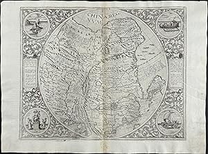
Map of China (China Regnum)
Editore: Antwerp, 1593
Da: Trillium Antique Prints & Rare Books, Franklin, TN, U.S.A.
Valutazione venditore:
Arte / Stampa / Poster
Condizione: Fine. This map is one of the most rare and sought after maps of China entitled China Regnum. It was the first de Jode map of China. It mapped China, part of Japan, Korea, Taiwan, and northern Philippines. It was based on the work of Jorge de Barbuda, a Portuguese cartographer, whose map appeared in Ortelius's 1584 publication of Theatrum. It was the second map of China to be printed in Europe.Description of the work:This truly significant map is from one of the rarest atlases ever published, Gerard and Cornelis de Jode's Speculum orbis Terrae. The work was published in Antwerp in 1593 by Arnold Coninx for the widow and heirs. This is considered the second edition, revised an expanded. The first edition was published in 1578. Van Ortroy knew of only 14 copies of the second edition being published. (Skelton, Introduction to the facsimile editions)De Jode drew upon his large stock of maps from Italian, German, and Flemish cartographers to create his atlas. He engraved some of the maps and his brothers, Joannes and Lucas van Deutecum, also contributed to the process. The second edition included additional maps from Gerard's son Cornelis. The maps have descriptive text to verso in Latin. The text for the first edition was written by the German scholar, Daniel Cellarius.The atlas contained some of the most groundbreaking maps ever published. The maps of the world, Americas, Australia, and China are of particular note and remain some of the most important maps ever published. While it may not have had commercial success at the time, it is considered a masterpiece of 16th century cartography. Very few examples of the maps have survived from either edition.Gerard de Jode (1521- 1591) was a Flemish cartographer, printer, and engraver. He produced and sold many maps in Antwerp, but his legacy lies in his outstanding atlas, Speculum Orbis Terrarum. De Jode was a contemporary and competitor of Abraham Ortelius. Ortelius was believed to have been responsible for delaying de Jode's work so his atlas Theatrum Orbis Terrarum would precede de Jode's. Because Ortelius's atlas had 8 years on the market it was well established and thus de Jode's atlas did not sell very well.To compete with Ortelius, de Jode worked on the second revised and expanded edition. De Jode's wife and son, Cornelis (1568-1600) took over the publishing upon Gerard's death in 1591. Cornelis prepared ten new maps of the World, North America, China, Australia and Alaska and re-issued the atlas. "Many of de Jodeâ s maps are judged to be superior to those of Ortelius, both in detail and style." (Burden)Antwerp publisher Joan Baptista Vrients purchased the plates after Cornelis's death. He also acquired Ortelius's plates for Theatrum Orbis Terrarum to which he gave priority. It is likely he bought de Jode's plates to prevent any further editions of Speculum of course only increasing the intrigue and worth of the maps today."Although the atlas may not have appealed to the public, it was admired by other cartographers. As evidence, Petrus Montanus mentions it in the same breath with Mercatorâ s Atlas and Orteliusâ Theatrum in his preface to Pieter Kaeriusâ Germaniae inferior (Wardington Catalogue), Michael von Aitzing refers to it in his work, DeLeone Belgico (1583). Von Aitzing intended his work to act also as a supplement to both the Theatrum of Ortelius and the Speculum of De Jode." (Burden)Provenance : Ownership inscription at the bottom of the title page ex Bibliotheca Prim d Federici 1600.References: Van der Krogt 32:02B (titles 32:2A and 32:2B) ; Koeman II, Jod 2 ; Shirley, The mapping of the world, 165,184 ; Burden, The mapping of America, 81, 82 ; Symour, L. Schwartz, Ehrenberg, The mapping of America, pp. 78-79 ; Norwich, Maps of Africa 19 ; Navari, Maps of Cyprus, 29 ; Tooley, Dictionnary of mapmakers II, p. 441 ; Tooley, Mapping of Australia,; Tooley, Arabia in early maps, 38 (1st ed.) ; Koeman, Schilder, van Egmond, van der Krogt, HOC,vol. 3 part 2, Commerc.
-
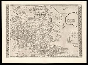
Asiae Novissima Tabula
Editore: Gerard Smits, [c1590]., Antwerp,, 1590
Da: Daniel Crouch Rare Books Ltd, London, Regno Unito
Membro dell'associazione: ABA ILAB PBFA
Valutazione venditore:
Mappa
Unrecorded second state of De Jode's map of Asia Double-page engraved map, Latin text to verso, watermark of a bunch of grapes within a shield, banner below, Briquet 13215. Unrecorded second state of Gerard de Jode's map of Asia. The map, published by Gerard de Jode in his 'Speculum Orbis Terrarum' in 1578, is not only one of the first maps to depict the Philippines, but also one of the earliest to name Singapore, here marked 'Cinapura'. The cartography is based on Mercator's seminal world map 'Nova et Aucta Orbis Terrae Descriptio', published in 1569. The work stretches from eastern Europe to the west coast of North America. Although Ortelius had included the west coast of America on his map of Southeast Asia 'Indiae Orientalis', published in 1570, its is highly unusual for maps of the whole continent to show America's coastline, with the only other sixteenth century example published in Solinus's Polyhistor of 1538. The present example has been heavily reworked and includes many additional place names, extending the map to the left and the right margins, heavily revising the west coast of America, together with the addition of two new engraved side borders. The additional names are: Mare Indicum (Indian Ocean); Mare Della China (The Sea of Japan/Korea); Aegeum Mare (Adriatic Sea); Mare del Sur (Pacific); Russia (Russia); Sarmatia Asiatica (Russia); Kondori (Russia); Europae pars Occidens (Western Europe); Candia Pars (Crete); Salonica (Thessaloniki); Belgian Mons (mountains in China); and Tangut (China). The left and right decorative borders have been erased to increase the works cartographic scope to include: in the west Thessaloniki, and Crete, and in the east a greater portion of the western coast of North America. The American coastline has been completely redrawn removing the lower section together with the place names: Tucano, Quivira, and Tiguex. The Asian coastline of the 'Stretto de Anio' (the mythical Straits of Anian) has also been remodelled. To the lower right of the map de Jode has included the 'Arcipelago d.s. Lazaro' (St Lazarus Islands). The name had originally been applied to the Philippines by Magellan, in 1521, as their first landfall on the archipelago had been on the day of the feast of St Lazarus. However as mapmakers such as Ramusio had underestimated the distance between the Marianas Islands and the Philippines, the distinction between the two were lost. Beginning with Ramusio (and copied by the likes of Ortelius) we see a tendency to push the name further east to denote islands of Micronesia, such as here. Finally de Jode has engraved two new borders, on two pieces of copper, which have here, been slighly set away from the maps copper plate. It would appear from the present example, and his map of the world 'Universi Orbis Seu Terreni Globi in Plano Effigies' - which is also known in later states - that Gerard was working on a second edition of the atlas before his death in 1591. Many of the revisions and additions to the present map are also evident on de Jode's wall map of Asia, published in around 1590 - the only surviving example of which is now housed in the Gottingen University Library. It is most likely that the publication of the wall map (Gerard also published maps of Africa, America, and Europe) acted as a catalyst for the present maps revision. Unfortunately the present state would have a very short life, as following Gerard's death in 1591 his son Cornelis in his edition of 1593 replaced all the continental maps with new plates based on the work of Gastaldi. Rarity We have been unable to trace another example of this state appearing at auction since the second world war. We have also been unable to trace any institutional examples. Gerard de Jode Gerard de Jode (1509-1591) was a cartographer and publisher. The 'Speculum Orbis Terrarum' was intended as competition for Abraham Ortelius' 'Theatrum Orbis Terrarum'. The two, who made their living partly as map-sellers, were competitors and apparently not always on good terms. It has been suggested that Ortelius was responsible for delaying the publication of de Jode's work, by using his extensive contacts to prevent de Jode's atlas being granted the necessary approbations (or privileges), as Ortelius wished to protect his own work. De Jode did not gain all the necessary approbations until 1577, some seven years after the publication of the 'Theatrum', the first copies of the 'Speculum' being sold at Plantin's shop in 1579. Ortelius' cunning plan would seem to have worked, as Plantin's records suggest that very few copies were actually sold. Although sales of de Jode's work were less than ideal, the work was evidently held in high regard, with several contemporary works citing its importance alongside the atlases of Mercator and Ortelius. Following Gerard's death in 1591, n expanded and revised edition was published by his son Cornelis in 1593.
-
Lenguaje Del Amor, El, De Reve, Gerard. Editorial Ultramar En Espa ol
Editore: FisicalBook
ISBN 10: 8473865472ISBN 13: 9788473865470
Libro
Condizione: New. Libro nuevo, sellado, fisico, original. Enviamos a todos el mundo por USPS, Fedex y DHL. 100% garantia en su compra. Sealed, new. Unopened. 100%guarentee. We ship worldwide.
-
Gerardi de Lairesse, Leodiensis pictoris, opus elegantissimum, Amstelaedami ipsa manu tam aeri incisum, quam inventum.Including: [LAIRESSE, Gerard de, and Nicolaas VISSCHER II]. Appendix. Diversae de signationes, Lairessaea quidem manu inventae et pictae, at aliorum sculptorum manibus artificiosissime aeri incisae et sumptibus Nicolai Visscher editae.[Amsterdam], [Nicolaas Visscher II], [ca. 1690?]. 1mo (52 x 39 cm). With a double-page engraved title-page, an engraved title-page of the appendix and more than 100 engraved illustrations on 56 large double leaves, including 31 double-page engravings. 18th-century half gold-tooled, sprinkled calf, decorated paper over boards, with a gold-tooled red morocco title-label on the spine.
Da: ASHER Rare Books, T Goy Houten, Paesi Bassi
Membro dell'associazione: ILAB NVVA
Valutazione venditore:
[50]; [8] double ll.Beautiful set of engraved illustrations by the Dutch Golden Age painter and engraver Gerard de Lairesse (1641-1711) in its first state, with the engravings bearing the imprint of N. Visscher. Almost all known copies of the present work show differences in contents and order of the plates. The present copy contains the large double-page engraved title-page, the engraved title-page of the appendix and more than 100 engraved illustrations of varying sizes on 56 double-page leaves, including 31 large double-page illustrations.Gerard de Laraisse was the son of the Ličge painter Renier Lairesse and followed in his father's footsteps. He moved to Amsterdam in 1666 to paint in the atelier of the art dealer Uilenburg, before starting out on his own. He became one of the famous painters and engravers of the Dutch Golden Age, producing works in a classic style depicting historical, allegorical and mythological subjects. His works were greatly appreciated during his lifetime and long after and he was sometimes even called the Dutch Poussin. Although Lairesse went blind in the 1690s, he was still able to earn his living teaching drawing and painting and writing instructional works on these matters. His lessons and works were all based on his own lifelong experience. De Lairesse's teachings also strongly influenced 18th-century book-illustration.With the bookplate of the Dutch art collector Joseph Augustin Brentano (1753-1821) on the front paste-down, with his signature at the foot of the bookplate in brown ink "J. A. Brentano".The binding shows slight signs of wear, slight foxing to the first few leaves and very slight foxing to the edges of the leaves throughout, the illustrations remain fine and clean. Overall in very good condition.l STCN 317791346 (3 copies); Timmers, Gérard Lairesse, 24; WorldCat 22670296 (4 copies); 900782756 (4 copies, incl. 1 the same as STCN); 740253279 (2 copies, same as STCN); 54212851 (1 copy); 835994396 (5 copies). For De Lairesse: Thieme Becker 22, p. 233-237.
-
Historia Mundi; or Mercator's Atlas. Containing his Cosmographical Description of the Fabricke and Figure of the World.
Editore: T. Cotes for Michael Sparke, 1635
Libro Prima edizione
Hardcover. Condizione: Very Good. 1st Edition. London: Printed by T. Cotes for Michael Sparke, 1635. Folio (11 2/8 x 7 inches). Engraved emblematic additional title-page (minor marginal restoration), 182 engraved maps by Hondius, R.Hall, Peter van der Keere and J. van Loon including a duplicate of "Hispania Nova" and three maps pasted on at pages 299, 581 and 818 (folding) ("The Meaning of the Frontispiece" leaf laid-down, marginal restoration to letterpress title-page, single worm-track through lower margins of leaves to Ggg1 affecting a few of the larger maps, map of "The Bishopric of Munster" with small repair to title, long early repaired tear to last leaf of text, a few marginal tears and occasional pale stain). Modern brown morocco gilt by Zaehnsdorf, each cover elaborately decorated small fleuron tools to form three horizontal and three vertical lines, the intersections marked with the armorial crest of the Pease family, the spine in six compartments with five raised bands, lettered in the second, the others with a repeat pattern made up from the fleuron and 'Pease-crest' tool, gilt turn-ins, all edges gilt. Provenance: Faint near contemporary ownership inscription of Thomas Most on letterpress title-page, and marginal annotations on pages about Egypt and the Holy Land; near contemporary signature of Robert Hare on the recto of "The Meaning of the Frontispiece" leaf; crest of the Pease family on binding. First printing in English, first issue with the verses on A2 verso are signed 'M.S'[parkes]; and most importantly a duplicate map of New Spain (Hhhh3 recto) in place of the later issued map of Virginia by Ralph Hall: "there is no Map for Virginia in regard there is a more exact Map drawing in that Country, whose Platforme is not yet come over, but when it comes, every buyer of the Booke shall have it given him gratis" (see errata on verso of final leaf). "Wye Saltonstall intended in his first edition of the "Historia Mundi" a map of Virginia. In acquiring the Mercator-Hondius copperplates used first in the "Atlas Minor" of 1607, he only possessed one of Virginia and Florida, which covers the area south of Chesapeake Bay. Since that time the Jamestown colony had become important, and a map would be needed to illustrate it. [Hall's] map was included in future editions of the "Historia Mundi" in 1637 and 1639" (Burden 244). Without the ninth state of the rare map of New England by John Smith found in some copies, nor the blank leaf between the last page of text and the "Table". STC 17824.5; Phillips 451 & 4255 (later issues); Sabin 32750. Purchased at Bonham's 4th December 2006, lot 6040.
-
Atlas, or A Geographicke description of the Regions, Countries and Kingdomes of the world, through Europe, Asia, Africa, and America. Translated by Henry Hexham.
Editore: Amsterdam: H. Hondius and J. Jansonnius, 1636., 1636
Libro Prima edizione
Hardcover. Condizione: Very Good. 1st Edition. Volume one, only (of 2). Folio (18 6/8 x 12 inches). Engraved title-page with letterpress overslips to the title and imprint, magnificent double-page engraved portrait of Mercator and Hondius, 81 engraved maps, including a fine example of Hondius' double-hemisphere world map (Shirley 336, state 1), six maps with amateur hand-colour in outline (map of Denmark with a repaired marginal tear, map of Prussia with frayed right hand edge). Modern half vellum marbled paper boards. Volume one only of the first English-language edition of Henricus Hondius and Joannes Janssonius's revision of Mercator's atlas, published in 1630 as a response to the growing threat of their competitor Willem Blaeu. The only atlas of the world to appear in English since the publication of Abraham Ortelius' "Theatrum Orbis Terrarum. The Theatre of the Whole World", published by John Norton in 1606. Each map is accompanied by descriptive text, bringing the glories of Charles I's empire, before it was torn apart by the Civil War, to a wider audience in a language that they could read. The wonderful double-hemisphere world map "is a fine ornate example of the decorative cartography of the time. The two hemispheres are bordered by voluptuous representations of the four elements and other scenes: in the top corners are portraits of Julius Caesar and Claudius Ptolemy and in the bottom corners are portraits of the author's father Jodocus Hondius and his mentor Gerard Mercator. For geographical detail Hondius has followed Speed and his contemporaries and also presents California as an island. New features include part of the north Australia coastline extending towards New Guinea and a redrawing of north-east Canada with 'Queen Anne's forland' (Baffin Island) shown completely circled by open water." (Shirley 336). The Hondius-Jansson world map was included in all issues of the Mercator atlas from 1633 to about 1658. Maps that relate to America include the world map, and the Poli Arctici, other maps are of England, Ireland, Scotland, northwest Europe and Greece. "Jodocus Hondius obtained the copper-plates of Mercator's atlases (Ptolemy's "Geographia" and the "Atlas") on 12 July 1604. He probably bought them at Leiden at the auction of Mercator's library, then in the possession of his grandson, Gerard Mercator, Jr. A partly new text to the maps was written by Petrus Montanus. after [Jodocus Hondius's] death, the widow with her seven children continued publishing the atlases under the name of Jodocus Hondius till 1620. The firm was reinforced by the very welcome help of Joannes Jansonius (1588-1664), who married 24-year-old Elizabeth Hondius in 1612. After 1619 the Atlas was published under the name of Henricus Hondius [Jodocus Hondius's son] (Koeman). Koeman II, Me 41a; Phillips Atlases 449.
-
Orbis terrae compendiosa descriptio.
Editore: [Geneva:] Rumold Mercator, 1587 (but Amsterdam:, Jocodius Hondius, Ca 1620., 1620
Single sheet, float mounted and framed (11 2/8 x 20 4/8 inches to the neat line). Fine engraved double-hemisphere map of the world set within an elaborate strapwork border with an armillary sphere and a compass rose in the cusps, all with original hand-colour in full (side margins renewed, one or two other repairs). THE FIRST DOUBLE-HEMISPHERE MAP OF THE WORLD. This striking map represents a re-working of Mercator's great world map of 1569 by his son and successor Rumold, who transformed it into double-hemispherical form in 1587 and incorporated it into editions of Mercator's influential atlas from 1595. This issue dates from the 1620s as the break marks at the top of the copper plate now extend through the title. Showing New Guinea as an island and Beach as a peninsula of Terra Australis. The engraving is a model of clarity and neatness, with typical cursive flourishes to the lettering of the sea names. Surrounding the hemispheres is a strapwork border, while between them at the top margin is an armillary sphere and at the bottom an elaborate compass rose. Gerard Mercator's prominent south-west bulge on the coastline of South America, which was soon to be corrected, is retained. This superb map represents a seminal moment in the history of cartography, for it was the primary instrument by which knowledge of Mercator's projection was diffused throughout Europe. Shirley 157. Catalogued by Kate Hunter.
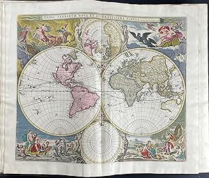
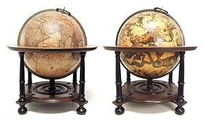

![Immagine del venditore per L'Atlas Ou Meditiations Cosmographiques De La Fabrique Du Monde et Figure Diceluy. Commence En Latin Par Le Tres Docte Gerard Mercator, Paracheve p[ar] Jodocus Hondius. Traduit En Francois Par Le Sieur [Henri Lancelot-Voisin] De La P[opliniere] venduto da Arader Galleries - AraderNYC](https://pictures.abebooks.com/inventory/md/md1140886551.jpg)

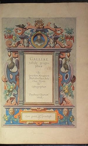
![Immagine del venditore per I. Geographiae libri octo, recognitiam diligenter. [II. Galliae Tabule Geographicae. Belgii Inferiores Geographicae Tabule]. venduto da JF LETENNEUR LIVRES RARES](https://pictures.abebooks.com/inventory/md/md22846645099.jpg)
![Immagine del venditore per Gerardi de Lairesse, Leodiensis pictoris, opus elegantissimum, Amstelaedami ipsa manu tam aeri incisum, quam inventum.Including: [LAIRESSE, Gerard de, and Nicolaas VISSCHER II]. Appendix. Diversae de signationes, Lairessaea quidem manu inventae et pictae, at aliorum sculptorum manibus artificiosissime aeri incisae et sumptibus Nicolai Visscher editae.[Amsterdam], [Nicolaas Visscher II], [ca. 1690?]. 1mo (52 x 39 cm). With a double-page engraved title-page, an engraved title-page of the appendix and more than 100 engraved illustrations on 56 large double leaves, including 31 double-page engravings. 18th-century half gold-tooled, sprinkled calf, decorated paper over boards, with a gold-tooled red morocco title-label on the spine. venduto da ASHER Rare Books](https://pictures.abebooks.com/inventory/md/md31599491756.jpg)